Creating boundaries: the (un)limited possibilities measured
January 1, 2015 / Jacques Vos
In this contribution, the difference between physical, legal, and cadastral boundaries will be explained. Afterwards, the introduction of provisional cadastral boundaries will be discussed in greater detail. By means of these provisional cadastral boundaries, the factual, legal, and cadastral situations are to be brought in greater compliance with each other. As a result, the legal reliability of the Cadastre, Land Registry and Mapping Agency of the Netherlands will be increased.
I. Introduction
When buying a (house on a) plot it is of great importance to know where the (cadastral) boundaries are located. A buyer would like to know where the boundaries are located that separate the plot that he would like to buy from the neighbouring plots. It gives him legal certainty. A physical plot boundary, such as a wall, a fence, or a hedge can be of assistance when visualizing the location of the boundaries and the shape of the plot. Yet, the physical boundary is not the decisive legal factor. The buyer will predominantly try to fathom which disadvantages are (or might be) attached to the present boundary location. This holds especially true when the factual boundary differs from the cadastral and/ or the legal boundary.
II.-Physical, cadastral and legal boundaries
In the ideal situation the physical boundary is also the cadastral and the legal boundary. In many situations this is yet not the case in the Netherlands[1].
It is possible that a part of certain plot has been in the possession of a person other than the original owner for a period of 10 (if in good faith)[2] or 20 (if in bad faith)[3] years. As long as the prescription period (“verjaringstermijn”) has not been elapsed, the physical boundary is not in compliance with the legal boundary. After the elapsing of the prescription period both types of boundaries coincide with each other. Regardless of the elapsing of the prescription period the physical – and possibly also legal – boundary will differ from the cadastral boundary. It is only after a declaration of prescription (“verklaring van verjaring”), a settlement (“vaststellingsovereenkomst”) or a court decision alluding to the prescription has been registered, that the cadastral boundary can be brought in compliance with the legal boundary.
Differentiating the legal from the cadastral boundary is of utmost importance. The legal boundary is essentially to be defined as the boundary that the parties have been agreed upon. The intention of the parties as expressed in the notarial deed of transfer[4] is decisive for the legal boundary. The cadastral boundary is the boundary which the parties allocate to the land surveyor of the Cadastre, Land Registry and Mapping Agency of the Netherlands, who then fixes this boundary. In most cases, the boundaries allocated by the parties complies with the boundary as described in the notarial deed of transfer. As a result, the legal boundary is the same than the cadastral boundary.
III. The difference between the legal and the cadastral boundary
Occasionally it occurs that the land surveyor asserts that the boundary allocation of the parties does not comply with the the boundary description, stated in the notarial deed of transfer. This is for example the case when the seller allocates (a part of) another cadastral plot as belonging to the plot that is subject to the transfer. As the intention of the parties, as follows from the registered deed, is decisive for answering the question where the legal boundaries of the plot are located[5], the new border(s) and therefore the plot will not be created by the land surveyor. The notary then receives a rectification request. However, under certain conditions, the notary might conclude that he cannot correct the deed[6].
In exceptional cases, updating of the registration can occur without identical allocation of the new boundaries by all parties involved[7]. This is only the case if the description of the position of the new boundaries in the registered deed does not raise any doubts and is – in the opinion of the land surveyor – not inconsistent with the perceived demarcation. However, in many cases a demarcation in the territory does not exist and a (sufficiently) detailed description of the boundary in the notarial deed is missing. In those (many) cases there are no new boundaries (and therefore no new plots) to be formed.
Lastly, the situation can occur in which it turns out afterwards that the parties have allocated a boundary as the cadastral boundary that does not comply with the legal reality. In such a situation, the intention of the parties, contained in the notarial deed of transfer, prevails over the allocation of the boundary by the parties in the presence of the land surveyor. The Supreme Court[8]interprets the cadastral description as being a tool for the identification of an immovable. The inclusion of the cadastral description in the notarial deed of transfer is not (always) sufficient (principle of speciality).
In the following it will be described how the forming of plots takes place. Special attention will be given to the problems surrounding ‘sketchy’ drawings and the absence of ‘hard topography’ that occur in daily practise.
IV. Splitting a priori
When splitting a plot before passing the notarial deed in two or more new plots, the current entitled person to the plot has to have the plot surveyed. In the process of splitting a priori this surveying takes place before the plot is legally transferred. The entitled person indicates to the land surveyor where the new boundary is to be located. Next to the entitled person the buyer of the plot, if known, will be invited to be present, when the boundary is allocated in the presence of the surveyor. Within a period of time of 20 days, the new plots will be formed. The newly formed cadastral boundaries, surfaces, and plot numbers are fixed at the point of time at which the notarial deed of transfer is passed. As a result, the notary can describe the newly formed plots by mentioning their unique plot number (cadastral parcel number) and therefore clarity exists for all involved parties as to what the object of the transfer shall be (principle of speciality). Yet, the definite determination of the boundary beforehand is not possible in all cases. Especially when it comes to newly to be built houses and projects to be developed, there is the risk attached to splitting a priori. It might be the case that the building will exceed the (newly formed) boundary, since the surveying has been done and afterwards the contractor starts creating the building. Plot forming often takes place after the notarial deed of transfer has been passed (the traditional plot forming). Thereby the risk of an encroachment upon adjoining land is prevented. The disadvantage of the ‘traditional plot forming’ is the significant period of time that lies between the registration of the notarial deed of transfer and the updating of the cadastre after the allocation of boundaries and surveying has taken place. This period can be up to 18 months.
V. ‘Traditional’ plot forming
After the notarial deed, which effectuates the transfer of a part of an already existing plot, is registered, the land surveyor fixes the new cadastral boundaries as has been agreed upon by the parties. The situation in which the land surveyor can state that the description of the location of the newly to be formed boundary as contained in the registered deed, excludes all doubts, occurs only in exceptional cases[9]. Furthermore, the description contained in the notarial deed in many cases conflicts with the witnessed demarcation in the territory. Seeing this, the land surveyor will in most cases have to ask the parties for further information.[10]
By means of this further information, provided by the parties as they allocate the boundary in the territory, the cadastral boundary can be fixed and the cadastre[11] can be updated. The entitled persons will be informed by means of a formal notice[12]. If the information needed for updating the cadastre have not been supplied of if this information is inconsistent, the updating of the cadastre cannot be proceeded[13]. Further, the updating of the cadastre will not occur if the boundary allocation of the parties differs from the description of the boundary location contained in the notarial deed[14]. The notary will then be asked to investigate whether a rectification of the notarial deed is possible. It is only after the notarial deed of correction has been registered that the updating of the cadastre can be completed[15]. If the notary however concludes that he cannot rectify because the party intentions, when the legal transfer took place, have been correctly expressed in the notarial deed, the annotation “plot forming postponed” will be included in the cadastre[16].
The period of time that lies between the moment of registration of the notarial deed, the invitation of the parties to allocate the boundaries, the allocation of the boundaries itself, the completion of the surveying process and the updating of the cadastre is significant. In this period there is often uncertainty about the location of the boundary – especially for third parties. This uncertainty increases if several parts of a plot or a part of a partial plot is transferred. This is often the case with complex new building projects, which are realized in different phases. It is only when the allocation of the boundaries by the parties takes place that concretion occurs and that it becomes clear where the boundaries, according to the parties, are to be located. If a mortgage is attached to the transferred partial plot, it is not always clear to which part of the plot the mortgage is to be connected. This is surely the case if the registered copy of the mortgage deed does not include an attached drawing which indicates to which part of the (partial) plot the mortgage is connected. In this case the registrar does not have a choice but to register the mortgage right on all parts of the plot that originated from the registration of the notarial deed of transfer. The result is a ‘cadastral contamination’ of all partial plots with – possibly – several mortgage rights. The legal certainty is not be served by this. Proposals to increase the legal certainty of the cadastre have been done by Klaasse and Louwman[17]. In addition, the system of provisional cadastral boundaries has been introduced.
VI. Increasing the legal certainty of the Cadastre, Land Registry and Mapping Agency
Klaasse and Louwman propose to also register drawings which indicate the surveying data and on which the boundaries in relation to the “hard topography” can be consulted in a simple manner, as attachments to the notarial deed. Such drawings prevent discrepancies between the boundary allocation and the party intention. Furthermore, third party effect can be conferred upon the exact location of the boundaries as expressed in the registered drawing. Additionally, Klaasse and Louwman propose to make use of the method of “tervisie legging” instead of the traditional boundary allocation. “Tervisie legging” entails that after the legal transfer took place, the plot forming is realized by allowing inspection of the drawing with sizing that belong to the registered deed. Both methods facilitate the legal certainty of the cadastre and the cadastral map. Next to the drawing with sizing and the procedure of “tervisielegging”, the possiblity to form provisional cadastral boundaries through the software application ‘Splits’ (which is provided to all notaries and municipalities by the Kadaster for free) that has been in existence since 2009.
VII. Introduction of provisional cadastral boundaries
The Kadaster works on a renewal of the way in which the cadastre (being the index to the land register) is filled. First, this occurs through the development of new software that is to replace the current registration system AKR (“Automatisering Kadaster Registratie”/ Automating Kadaster Registration). Second, this renewal is facilitated by an automated processing of notarial deeds to the greatest extent possible through the so-called KIK (“Ketenintegratie Inschrijving Kadaster”/ Chain Integration Program) program[18].
KIK does not leave room for interpretation of the notarial deed on the basis of which the cadastre is updated, as use is made of pre-approved style sheets with set blanks. Due to the fact that a computer system on itself cannot do (sufficiently reliable) interpretations, it is not possible to transfer a part of a cadastral plot. After all, it has to be completely clear which part of a plot is transferred or burdened with a mortgage. Especially in cases in which a part of a partial plot is being transferred, it is not always sufficiently clear which part of the plot is to be subject to the transfer. Interpretation of the (description of the relevant part of the plot in the) notarial deed is therefore (in many cases) necessary.
Furthermore, a considerable period of time lapses between the moment in which the notarial deed of transfer of a part of a plot is registered and the cadastral surveying and updating of the cadastre. As splitting a priori is not always possible, a different method had to be developed. Affiliation was sought to the greatest possible extent with the working procedure of the notarial profession. A sofware application, called ‘Splits’, has been developed and provided for free to the notaries and some other (government) parties. With the assistance of this application it is possible for the user (being entrusted by his client) to draw (in the cadastral map) provisional cadastral boundaries in a plot by himself. Thereby, the plot is split in two or more new cadastral plots. Through Splits the notary can serve his clients in manner that is as optimal as possible. Another advantage is the – compared to the traditional lengthy process of plot forming – short period of time in which a provisional cadastral boundary can be formed: within five days new plots are formed. Next to that, the notary can use the new unique plot identification number in the deed. Because of this unique number, computerised processing of the deed (using the KIK program) is possible, which means the deed will be processed at a faster, more secure (no mistakes) and cheaper manner.
Before the application can be used, an introduction course is necessary. During this course the possibilities and limitations of the application are explained to the users. A notary that draws such a boundary is expected to act in his capacity as notary being entrusted by the right holders. By drawing a line in the Splits application, a provisional cadastral boundary is drawn. In addition, a provisional cadastral size of the newly formed plots is received. Due to the fact that the cadastral indication is fixed, it is included in the notarial deed of transfer by the notary. The notary therefore no longer describes the part of the plot. The annotation “Provisional cadastral boundary and surface” is attached to the new plot numbers in the cadastre, so that it is clear for everybody that the cadastral indication is definite but that the cadastral boundary and the surface is not (yet).
VIII. The meaning of the provisional cadastral boundary
A provisional cadastral boundary is a line that is indicated by or on behalf of the owner of the plot, through which a cadastral plot is split in two (or more) new plots. This line is not yet surveyed by the Kadaster so that the plots are not definitely formed yet. The so-called verification surveying, the surveying that follows some time after the notarial deed of transfer is registered, takes place at a later point of time. The verification surveying follows for the most part the same procedure than the surveying process that is applicable to partial cadastral plots. The parties mentioned in the notarial deed allocate the boundaries in the territory to the land surveyor who controls whether the allocated boundaries are in conformity with the provisionally formed boundary and the content of the notarial deed.
When it comes to a notarial deed of transfer of a partial plot, use is sometimes made of a (by preference registered) drawing that is attached to the deed; when using Splits a line is drawn. Attaching – and registering (!) – a drawing is in the context of partial plots very much desired, as explaned before. If a deed mentions a provisional cadastral boundary, the attachement of a drawing is yet not desired. After all, through the use of the Splits application, a sketchy drawing for the benefit of the verification surveying by the land surveyor exists; the land surveyor can read out the drawn boundary line that the Kadaster is provided with by the Splits application. If a sketchy drawing is attached additionally, it has to be controlled whether the location of the boundary that is to be newly formed complies with the boundary allocation as indicated in the Splits application. A discrepance between the attached drawing and the drawn line in the Splits application then (might) lead(s) to a VTV (“Verzoek tot Verbetering”/ Request for Revision). As long as the deed in which a partial plot is transferred has not been passed, the drawing can still be changed. The same holds true for a deed with a provisional cadastral boundary; the line in the Splits application can still be changed until the deed is passed and registered. When the location of the boundaries is changed in Splits, the applicant (the right holder or the notary) receives a new order number. In order to assure that the parties, the notary, and the land surveyor depart from the correct boundary line, a reference to this order number has to be included in the deed.
IX. Rectification requests
Parties allocate, in the presence of the land surveyor, the boundary in the territory. In practise, it appears that it can occur sometimes that the boundary allocated by the parties does not conform to the boundary description in the notarial deed or to the drawing that is attached to the deed. This does not merely hold true for situations in which a partial plot is formed, but can also apply to situations in which the Splits application is used and a provisional cadastral map is formed. Even the Splits application cannot prevent that the sketchy drawing (in case of provisional cadastral boundaries this is the line that is drawn in Splits) deviates from the boundary allocation of the parties (during the verification surveying) in the territory. Therefore, both the Kadaster and the notarial profession are dependent on what the parties allocate in the territory.
The casuistry determines on a case to case basis whether plot forming can take place when there is a difference between (in case of ‘traditional’ plot forming: the drawing, or in case of provisional cadastral boundaries:) the boundary line in Splits and the allocation of the parties.
A multiplicity of general starting points are handled. The shape, the location, and the size of the allocated parcel is to comply as much as possible with the sketchy drawing resp. the boundary line in Splits. In unbuilt areas a greater deviation in size is tolerated than in built-up areas, where the location of the boundary often can be related to so-called reference objects, objects of hard topography (buildings).
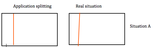
If in the application for a provisional cadastral boundary or in the notarial deed of transfer with a sketchy drawing a plumb line is drawn, while during the verification surveying (or after registration of a deed with a partial plot) the parties allocate a boundary that is not completely vertical (situation A), the sketch will be considered to be in compliance with the allocation of the parties.
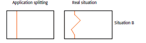
In situation B, the sketch, qua shape, extensively differs from the allocation of the parties. In this situation, a VTV (“Verzoek tot Verbetering”/ Request for Revision) will be sent. The notary might conclude that he does not wish to rectify. It is possible that another (reciprocally) transfer activity is necessary.
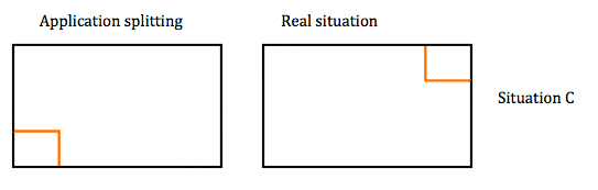
In situation C, the size and the shape of the split parcel conforms to the allocation, only the location differs. In this situation, the sketch will not be considered to be in conformity with the allocation and a rectification will be requested. Also in this case, the notary could decide against rectification.
X. Fictitious boundaries
As already mentioned, the plot forming will be postponed if the notary indicates that he will not rectify his deed and/or if the parties do not unanimously allocate where the cadastral boundary is located. This will be made visible in the registration through including the annotation “plot forming postponed”. It is new that in this case an administrative boundary will be formed.
The administrative boundary is a boundary which is applied by the Kadaster in situations in which parties have not reached agreement about the location of the boundary. In order to prevent that in future partial plots will come or stay in existence, a boundary line of purely administrative nature will be drawn. The existing plot, a part of which is transferred, will be administratively speaking split in two (or more) new plots which will be furnished with a definite cadastral indication with a provisional cadastral seize and an administrative boundary. This boundary will not be visible or will be visible by using a different colour on the cadastral map for third party consultants. The consultant will then simply see on the cadastral map (in the cadastral plot that has been administratively split) two cadastral indications resp. a boundary with a different colour. In the cadastre, the annotation “administrative boundary” will be shown in the respective plot. Through these means it will be for everybody clear that it does not concern definitive plot forming.
XI. Rates
Due to legal certainty, the formation of partial plots needs to be prevented as far as possible. Partial plots, after all, lead to cloudiness over the cadastral boundary. When it comes to a consequent order or to a burden of the partial plot with a property right it is not always clear which partial plot is transferred or burdened. This is why a lower rate will be charged for a notarial deed of transfer with a provisional cadastral boundary than for a notarial deed of transfer in which a part of plot is transferred. The low surveying rate for a plot with a surface of a maximum of 100 m2 and a purchase price or a return service of a value of a maximum of 5000,- is per January 1, 2014 abolished if the surveying occurs in the traditional way. The lower rate will only be charged for smaller plots which are formed on the basis of provisional cadastral boundaries.
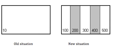
In the first phase a rate, which was to be due after the drawing of the line in the Splits application, was proposed. However, the notary may not prefinance the due rates that are to paid by his clients. This is the reason why the decision was taken to not demand the whole rate in one, but instead to split the rate. A relatively low amount is now charged when the application for splitting is offered and the remainder when the notarial deed of transfer is registered. The relatively low amount will be charged by the Kadaster from the applicant of the provisional boundary – the person that draws the boundary in the Splits application and that submits the application. When determining the rate, the following formula is used: the number of new plots minus the number of old plots. In the example given below, the rate is charged 4 times for the submission of an application for splitting (5 new plots – 1 old plot)
As long as the rights holder situation does not change with regard to the newly formed plots, a rate for surveying activities will not be charged as a (verification) surveying will not take place. At the moment in which a change in the legal situation with regard to one of the newly formed plots will occur for the first time (thus by registering a notarial deed of transfer), the Kadaster will charge, in addition to the rate for the registration of the notarial deed of transfer, also a rate for the realization of the verification activities.
The existence of a provisional cadastral boundary is indicated as an orange/brown boundary line on the cadastral map. Furthermore, the annotation “provisional cadastral boundary and surface” is indicated in the cadastre. That way, a notary can see the status of the boundary and draw conclusions with regard to the verification activities that have to take place.
XII. Description in the notarial deed
Due to the fact that during the processing of a notarial deed, that is offered for registration, the Kadaster employee does not consult the cadastral map (and therefore it is not visible for him or her whether it concerns a so-called “rest plot”). It is necessary for the notary to, also with regard to provisional cadastral boundaries, indicate this in the notarial deed. In the future a simpler registration system will be introduced. It is the intention that the provisional cadastral boundaries can then be processed in an automated manner. Until this is realized, it is unfortunately necessary to include the information needed for a correct application of the deed in the notarial deed.
When indicating a plot with provisional cadastral boundaries, the notary can suffice by stating a specific text. The same applies for the situation where a so-called “rest plot” is concerned (please see the first figure under the header ‘Rate’, where one plot is split in five plots and two plots are surveyed). In this case, another specific formulation can be used in each of the notarial deeds of transfer. With this formulation it is clear for the Kadaster that the plot transferred by this deed does not need to be surveyed anymore and that a rate for surveying activities does not need to be charged. The notaries who do not include this formulation in the deed will find the rate for surveying activities on their invoice. Fixing afterwards is possible by filing an application for restitution, which refers to the registered rectification deed through which this omission is repaired.
If the plots is already transferred en the entire plot is subsequently transferred again before the verification surveying could have taken place, the notarial deed of transfer, in order to prevent the charging of the verification rate, has to expressly indicate (preferably in the object description) that it concerns a subsequent transfer. Again a specific text can be included in the deed.
Until this moment, notaries are asked to add specific texts in their deeds, as explained before. As soon as the Kadaster has built a complete new registration system for the cadastre, these texts will not be necessary any longer. Prior to the completion of the new registration system, the Kadaster is investigating the possibilities to add a unique code to the newly formed boundaries by the application Splits. This unique code than should be sent to the notary involved, who sends the deed, accompanied with this unique code to the Kadaster. This code should be used during the registration process in the current cadastre registration system, just to prevent the notary has to add texts in the deed with the sole purpose to facilitate the Kadaster`s registration process.
XIII. Phasing out of partial plots
In practise, the description contained in the notarial deed does not sufficiently precisely describe the location of the boundaries of a part of a plot so that on the basis thereof plot forming cannot occur. As the rights holder, or the notary on his behalf, has added the location of the boundaries of the new plot to the cadastral map by drawing lines in the Splits application himself, such a detailed description is not necessary for the surveying process. Despite the fact that the description of the location of the boundary takes place by drawing lines in Splits, it seems to be advisable to describe the boundary in the deed as precisely as possible.
With the introduction and the use of the provisional cadastral boundaries, an end of the forming of partial plots is in sight. It is the intention to abolish the possibility to register a deed with one or more partial plots per January 1, 2015 if this deed does not foresee in a (sketchy) drawing on which the new to be formed boundaries are indicated. In addition to this possibility, plot forming will also be possible by using the possibility of ‘splitting a priori’ via the Splits application previously to the passing of the deed. As a result the legal certainty will be increased, the cadastral processing will be simplified and the cadastre willl better connect to the (intended) legal situation.
XIV. Possible future process
Trying to look into the future, using current (and possible future) techniques, it might be possible that the entitled person (seller) and the buyer of a part of the plot use the official (to be developed) Kadaster surveying app on their mobile device. The check on their identity is secured by the use of a qualified electronic signature on their mobile devices (using biometrical features), as accepted by the acreditated Trusted Services Provider. The entitlement of the current owner is automatically checked by the app, looking into the cadastre and verifying the applying person certainly is the current entitled person. Both persons use their mobile device (equipped with Global Positioning System) and together they walk along the new to be formed border. If both do agree on the boundary line, visualised on the screen in the app, they approve the new to be formed boundary by placing their electronic signature. The underlying coordinates will be used to update the cadastral map and can be sent (optionally) to the (European) conveyancing authority, which is known by the Kadaster. The application of this authority receives the data and adds the information in the electronic file (and draft deed). After registration of the deed, the new boundary is fixed and two (or more) new plots are created.
Footnotes
- Because of the merged organisation the tasks of the Kadaster – the Cadastre, Land Registry and Mapping Agency of the Netherlands – are not only the registration of deeds in the land register and updating the cadastre in accordance with these deeds, but also surveying, measuring and publishing (new) cadastral boundaries. In the Netherlands there are no legal boundaries recorded in the cadastre or the land register, other than the boundaries that are mentioned in the deeds that have been recorded. Of course it is key that the cadastral boundaries are (as much as possible) the same and in accordance with the legal boundaries.
- Article 99 of book 3 of the Dutch Civil Code.
- Article 105 of book 3 of the Dutch Civil Code.
- In the Netherlands a deed of transfer is needed to transfer ownership. In most cases, the deed is preceded by a contract of sale, which can also be registered in the land register.
- Dutch Supreme Court decision in case Van Poppering/Daems, HR 22 april 1989, NJ 1989, 754.
- Regarding the possiblities to answer a rectification request see my contribution in Juridische Berichten Notariaat 2013, nr. 21 (only available in Dutch).
- Article 14 paragraph 3 Dutch Cadastre Enactment (“Kadasterbesluit”).
- Dutch Supreme Court decision in case Dukker/ Los, HR 2 december 1988, NJ 1989, 160.
- Article 14 paragraph 3 Cadastre Enactment (“Kadasterbesluit”).
- Article 57 Dutch Cadastre Act (“Kadasterwet”).
- The cadastre, being the official index to the land register, also one of the key (or authentic) registers in a system of key (authentic) registers in the Netherlands, as explained in J. Vos, Authentic Registers in the Netherlands. Technical ambition in relation to reliability and legal certainty, in ELRA Annual Publication no 4 (2011), p. 67-79.
- Article 58 Dutch Cadastre Act (“Kadasterwet”).
- Article 57 paragraph 3 Dutch Cadastre Act jo article 14 paragraph 1 Dutch Cadastre Enactment (“Kadasterbesluit”).
- Article 59 paragraph 3 Dutch Cadastre Act (“Kadasterwet”).
- Article 59 paragraph 2 Dutch Cadastre Act (“Kadasterwet”) jo article 16 paragraph 3 Dutch Cadastre Enactment (“Kadasterbesluit”).
- For more detailed information regarding the process of rectifying a deed, see J. Vos, Het rectificatieproces bij het Kadaster, Juridische Berichten Notariaat 2013, number 21 (only available in Dutch).
- W. Louwman & Z. Klaasse, Vergroting juridische betrouwbaarheid Kadaster, Weekblad voor Privaatrecht Noariaat en Registratie 2007, 6728, p. 885-889 (only available in Dutch).
- The chain integration program is mentioned in J. Vos, Using European legislation & electronic means in cross border conveyancing; the end of lawyers or stimulating the European single market, in ELRA Annual Publication no 5 (2013), p. 118 and has been described in contributions in Juridische Berichten Notariaat 2009, numbers 14 and 22 and 2011, number 3 (only available in Dutch).